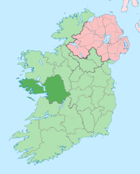
County Galway
| County Galway Contae na Gaillimhe |
||
 |
||
|---|---|---|
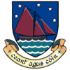
| Motto: Ceart agus Cóir (Irish) "Righteousness and Justice" |
||
| Location | ||
|
||
| Statistics | ||
| Province: | Connacht | |
| County seat: | Galway | |
| Code: | G (GY proposed) | |
| Area: | 6,148 km2 (2,374 sq mi) (2nd) | |
| Population (2006) | 231,670 (5th) (including Galway City) 159,236 (without Galway City) |
|
| Website: www.galway.ie | ||
County Galway (Irish: Contae na Gaillimhe) is one of the twenty-six counties of the Republic of Ireland and one of the thirty-two counties of Ireland. It is located in the province of Connacht. It was named after the city of Galway (Irish: Gaillimh). There are several strongly Irish-speaking areas (gaeltachts) in the west of the county. The population of the county is 231,670 according to the 2006 census.[1]
Contents |
History
The first inhabitants in the Galway area arrived over 7000 years ago. Shell middens tell us about the existence of people as early as 5000 BC.
The county originally comprised several kingdoms and territories which predate the formation of the county c. 1569.
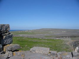
A number of inhabited islands are administered by the county; they include Oileáin Árann (Aran Islands) and Inis Bó Fine (Inishbofin).
With the arrival of Christianity many monasteries were built, and written records of events in the area and of its people were kept. These were followed by a number of law-tracts, genealogies, annals and miscellaneous accounts. Extant manuscripts containing references to Galway include:
|
|
Local government
- County Galway is part of the North–West constituency for the purposes of European elections.
- County Galway is divided into two electoral constituencies for the purposes of electing TDs to Dáil Éireann during general elections. These are Galway East and Galway West.
- Many smaller constituencies exist for the purposes of local elections.
- The local county administration is provided by Galway County Council.
Geography
County Galway is home to Lough Corrib (the largest lake in the Republic of Ireland) the Na Beanna Beola (Twelve Bens) mountain range, Na Sléibhte Mhám Toirc (the Maum Turk mountains), and the low mountains of Sliabh Echtghe (Slieve Aughty). The highest point in the county is one of the Twelve Bens, Benbaun, at 729m.
Climate
The location of County Galway, situated on the west coast of Ireland, allows it to be directly influenced by the Gulf-Stream. Temperature extremes are rare and short lived, though inland areas, particularly east of the Corrib, can boast some of the highest recorded temperatures of the summer in the island of Ireland (sometimes exceeding 30 °C); though these temperatures only occur when land warmed east winds sweep the area; the opposite effect can occur in the winter. Overall, however, Galway is influenced mainly by Atlantic airstreams which bring ample rainfall in between the fleeting sunshine. Rainfall occurs in every month of the year, though the late autumn and winter months can be particularly wet as Atlantic cyclonic activity increases and passes over and around the area, and which is why Galway tends to bear the brunt of severe windstorms that can occur between August and March. The county on average receives about 1300mm of rainfall annually, though some areas along the west coast of the county can receive up to 1900mm and beyond. Extreme weather such as blizzards, thunderstorms, flashflooding and hail, though rare, can and do occur, particularly when air masses of continental origin are undercut by more humid and unstable Atlantic flows.
Flora and fauna
One of the least densely-populated counties, County Galway harbors a variety of wildlife. The region's biodiversity is best represented by Connemara National Park, situated in the west of the county.
Towns and villages
| Historical populations | ||
|---|---|---|
| Year | Pop. | %± |
| 1659 | 33,390 | — |
| 1821 | 169,503 | 407.6% |
| 1831 | 204,691 | 20.8% |
| 1841 | 440,198 | 115.1% |
| 1851 | 321,684 | −26.9% |
| 1861 | 271,478 | −15.6% |
| 1871 | 248,458 | −8.5% |
| 1881 | 242,005 | −2.6% |
| 1891 | 214,712 | −11.3% |
| 1901 | 192,549 | −10.3% |
| 1911 | 182,224 | −5.4% |
| 1926 | 169,366 | −7.1% |
| 1936 | 168,198 | −0.7% |
| 1946 | 165,201 | −1.8% |
| 1951 | 160,204 | −3.0% |
| 1956 | 155,553 | −2.9% |
| 1961 | 149,887 | −3.6% |
| 1966 | 148,340 | −1.0% |
| 1971 | 149,223 | 0.6% |
| 1979 | 167,838 | 12.5% |
| 1981 | 172,018 | 2.5% |
| 1986 | 178,552 | 3.8% |
| 1991 | 180,364 | 1.0% |
| 1996 | 188,854 | 4.7% |
| 2002 | 209,077 | 10.7% |
| 2006 | 231,670 | 10.8% |
| [2][3][4][5][6][7] | ||
- Ahascragh
- Ardrahan
- Athenry
- Aughrim
- Ballinasloe
- Ballinderreen
- Ballyconneely
- Ballygar
- Ballymacward
- Ballymoe
- Ballynahinch
- Barna
- Bealadangan
- Bullaun
- Camus
- Carnmore
- Carraroe
- Casla
- Castleblakeney
- Castlegar
- Claregalway
- Clarinbridge
- Cleggan
- Clifden
- Clonbur
- Corofin
- Corrandulla
- Corr na Móna
- Craughwell
- Dunmore
- Eyrecourt
- Furbo
- Glenamaddy
- Gort
- Headford
- Hollygrove
- Inverin
- Kilcolgan
- Kilconnell
- Kilkerrin
- Kilkieran
- Killimor
- Kilronan
- Kiltullagh
- Kinvara
- Laurencetown
- Leenaun
- Lettercallow
- Letterfrack
- Lettermore
- Loughrea
- Maam Cross
- Maum
- Menlough
- Monivea
- Mountbellew
- Moycullen
- Muckanaghederdauhaulia
- Maree
- Newbridge
- New Inn
- Oranmore
- Oughterard
- Peterswell
- Portumna
- Recess
- Rosmuck
- Rossaveal
- Roundstone
- Roscam
- Skehana
- Spiddal
- Tuam
- Turloughmore
- Williamstown
- Woodford
See also
- Connacht Irish
- Galway East (Dáil Éireann constituency)
- Galway West (Dáil Éireann constituency)
- Galway GAA
- List of abbeys and priories in Ireland (County Galway)
References
- ↑ Census 2006 - Population of each province, county and city
- ↑ For 1653 and 1659 figures from Civil Survey Census of those years, Paper of Mr Hardinge to Royal Irish Academy March 14, 1865.
- ↑ Census for post 1821 figures.
- ↑ http://www.histpop.org
- ↑ http://www.nisranew.nisra.gov.uk/census
- ↑ Lee, JJ (1981). "On the accuracy of the Pre-famine Irish censuses". In Goldstrom, J. M.; Clarkson, L. A.. Irish Population, Economy, and Society: Essays in Honour of the Late K. H. Connell. Oxford, England: Clarendon Press.
- ↑ Mokyr, Joel; O Grada, Cormac (November). "New Developments in Irish Population History, 1700-1850". The Economic History Review 37 (4): 473–488. doi:10.1111/j.1468-0289.1984.tb00344.x. http://www3.interscience.wiley.com/journal/120035880/abstract.
- History of Galway, James Hardiman, 1820
- Education in the Diocese of Kilmachduagh in the nineteenth century, Sr. Mary de Lourdes Fahy, Convent of Mercy, Gort, 1972
- The Anglo-Normans and their castles in County Galway, Patrick Holland, pp. 1–26, in Galway:History and Society, 1996. ISBN 0 906602 75 0
- From Warlords to Landlords: Political and Social Change in Galway 1540-1640, Bernadette Cunningham, pp. 97–130, op.cit.
- The Politics of the 'Protestant Ascendency': County Galway 1650-1832, James Kelly, pp. 229–270, op.cit.
- The Galway Tribes as Landowners and Gentry, Patrick Melville, pp. 319–370, op.cit.
- Scríobhaithe Lámhscríbhinní Gaeilge i nGaillimh 1700-1900, William Mahon, pp. 623–250, op.cit.
- Early Eccleiastical Settlement Names of County Galway, Dónall Mac Giolla Easpaig, pp. 795–816, op. cit
External links
- Galway County Council
- Tourist information website
- Map of Galway
- *FLIRT FM* Galways Student Radio Station NUIG/GMIT
- Galway GAA
- County Galway Guide
- / local newspaper
- Extensive list of places in County Galway.
|
||||||||||||||||||||